
Photo Album: Eastern Cape to Garden Route
Note: Click an image to enlarge, tap "ESC" key to return.
Links for previous posts are on the left. Expand the month tags to see posts for that month.
Simons Town is a quiet little place, the manager of Cheriton Guest House, which I checked in for the night pointed me to a nice little restaurant by the beach. The food was surprisingly fine and excellent and the services very good. I must say that for the most part of this trip from Johannesburg through Northern Botswana and Namibia to here, I have met with good services and good quality of services, and hygiene standards etc. Not withstanding the very violent day-1 I had in Johannesburg, and the laughable traffic police who asked for money outside of Francistown. I have found Southern Africa so far to be quite safe and offers quite good standard of tourist services.
The morning at Simons Town was bright and sunny. I had a very quiet breakfast, continuing the slower pace since arriving Cape Town a few days ago.


The manager, a Dutch. took me into his inner sanctum, showing me his excellent wonderful collection of classic cameras....I have a couple of them at home, which I thought may fit in there somewhere.

After bidding goodbye with my friendly host, I was on the road again, along the shores of False Bay, moving towards Cape Agulhas, the Southern-most point of the African Continent.

In between quaint little middle class looking villages, there are big sandy beaches, in many ways, it reminds me of the Great Ocean Rd. outside of Melbourne, Australia.


And there are also big shanty towns, legacy of the apartheid era, still hiding behind sand dunes.

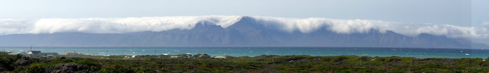
And some majestic looking mountains and rugged shore lines.


These stretches are very much Ocean Road like.


Wondered what the weather is like on the other side.


After passing Kleinmond, the scenery changed from rugger shores, to great plains, and the weather was definitely turning more cloudy.


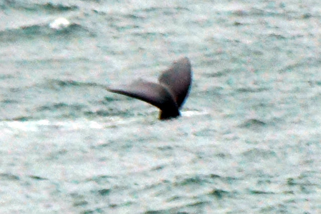
And the famous whale watching spot at Hermanus did not disappoint, and one can just sit there with a cup of something, binoculars ready.


By late afternoon, I was driving through Agulhas National Park, on my final approach to Cape L'Agulhas.

And here I was, nearly 350 Km from Cape of Good Hope.

At the start of this trip over 6 weeks ago, Ebola was beginning to ravage Western Africa, and I received many messages from family members and friends to return home.
But you can see from my footprint map below, how far had I been from the Ebola affected regions of Western Africa, it is half a globe away !


A morning's quick visit to the dividing line between the Atlantic and Indian Oceans, and the Southern-most point of the African Continent marked another milestone of this long road trip so far.


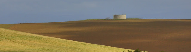
It is a remarkable point in an unremarkable landscape, just a plain old rocky beach with plenty of rugged reefs.


Being the Southern-most Point of a Continent and a dividing line of two great oceans, there must be a lighthouse and a few ship wrecks....sure !


Continuing on, the next point of interest to explore is the Arniston Cave, a sea cave which is only accessible at low tide. This is located at Waehuiskrans Beach 40 Km east of Cape L'Agulhas.


Fortunately it was low tide when I got there, and was able to walk through the cave through the sea entrance, but not without scrambling over a couple of wet rocks.


Don't really know what these colourful sea creatures that are trapped in the pot holes when the water receded.


My next destination was to reach Mossel Bay for the evening, connecting up with the famous Garden Route of South Africa, a popular self drive touring route.
Further north, the little town of Bredasdorp's small musem offers a glimpse into the marine history of Cape Agulhas region,


and the daily lives of the early European settlers.


As I had a bit of time on my hand, I decided to drive into the mountains, before heading east towards Mossel Bay.


Spring was definitely in the air.

After passing a few black South African villages, I was back on the east-west Highway 2 towards Mossel Bay.


Mossel Bay is the point of where I would join the popular and scenic self drive touring route, Garden Route, going east.

In between quaint little middle class looking villages, there are big sandy beaches, in many ways, it reminds me of the Great Ocean Rd. outside of Melbourne, Australia.


And there are also big shanty towns, legacy of the apartheid era, still hiding behind sand dunes.

And some majestic looking mountains and rugged shore lines.


These stretches are very much Ocean Road like.


Wondered what the weather is like on the other side.


After passing Kleinmond, the scenery changed from rugger shores, to great plains, and the weather was definitely turning more cloudy.


And the famous whale watching spot at Hermanus did not disappoint, and one can just sit there with a cup of something, binoculars ready.


By late afternoon, I was driving through Agulhas National Park, on my final approach to Cape L'Agulhas.

And here I was, nearly 350 Km from Cape of Good Hope.

At the start of this trip over 6 weeks ago, Ebola was beginning to ravage Western Africa, and I received many messages from family members and friends to return home.
But you can see from my footprint map below, how far had I been from the Ebola affected regions of Western Africa, it is half a globe away !


A morning's quick visit to the dividing line between the Atlantic and Indian Oceans, and the Southern-most point of the African Continent marked another milestone of this long road trip so far.


It is a remarkable point in an unremarkable landscape, just a plain old rocky beach with plenty of rugged reefs.


Being the Southern-most Point of a Continent and a dividing line of two great oceans, there must be a lighthouse and a few ship wrecks....sure !


Continuing on, the next point of interest to explore is the Arniston Cave, a sea cave which is only accessible at low tide. This is located at Waehuiskrans Beach 40 Km east of Cape L'Agulhas.


Fortunately it was low tide when I got there, and was able to walk through the cave through the sea entrance, but not without scrambling over a couple of wet rocks.


Don't really know what these colourful sea creatures that are trapped in the pot holes when the water receded.


My next destination was to reach Mossel Bay for the evening, connecting up with the famous Garden Route of South Africa, a popular self drive touring route.
Further north, the little town of Bredasdorp's small musem offers a glimpse into the marine history of Cape Agulhas region,


and the daily lives of the early European settlers.


 |
| The Ninth Edition of Encyclopedia Britannica, circa 1889 |

As I had a bit of time on my hand, I decided to drive into the mountains, before heading east towards Mossel Bay.

The roads are all excellent and the scenery did not disappoint.


Spring was definitely in the air.
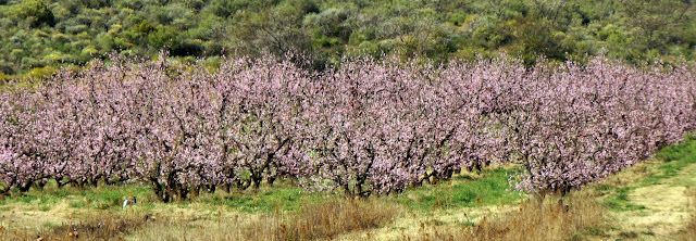 |
| Blossom flowers were in full bloom |

After passing a few black South African villages, I was back on the east-west Highway 2 towards Mossel Bay.


Mossel Bay is the point of where I would join the popular and scenic self drive touring route, Garden Route, going east.


